

Tirana
In 1614 a pasha returning from the campaigns in Persia, Sulejman Bargjini, stopped on a plain crossed by a river and surrounded by...
Updated 8 July 2026
Tirana
Explore
Towns in the province
This season · July · Summer
What to do in Tirana now
The story
The story of Tirana
From Ottoman origins to the twentieth-century capital
Before 1614 the area had been inhabited since antiquity, as testified by the remains of Illyrian settlements and a sixth-century early Christian basilica discovered in the city center. But it is with the Ottoman foundation by Sulejman Bargjini that the urban fabric still recognizable today was born: the bazaar, the mosque, the clock tower. For centuries Tirana grew as a provincial agricultural market, a hub between the coast and the mountains of the interior, never aspiring to the role of capital. The leap came with the proclamation of Albanian independence in 1912 and the turmoil of the following decades: in 1920 the Congress of Lushnjë designated it as the provisional seat of government, and in 1925, under Ahmet Zogu, it became the definitive capital, launching an urban plan entrusted to Italian architects who redesigned its center with monumental avenues and buildings in the Fascist-era style.
The communist regime and its architectural legacy
After the Second World War, under Enver Hoxha, Tirana became the urban laboratory of one of the most isolationist regimes in Europe. Skanderbeg Square was expanded beyond measure to host parades and mass rallies, while new residential districts in socialist style rose at the edges of the historic city. The country closed itself off almost hermetically from the outside world between the 1960s and the late 1980s, and this isolation translated into an architecture of representation, made of palaces of the people, monuments to the partisan resistance, and thousands of bunkers scattered across the entire national territory, many of which are still visible today even in the province of Tirana, among the hills and along the roads leading into the capital, physical testimony to a state paranoia that lasted a generation.
Skanderbeg Square, the nation's living room
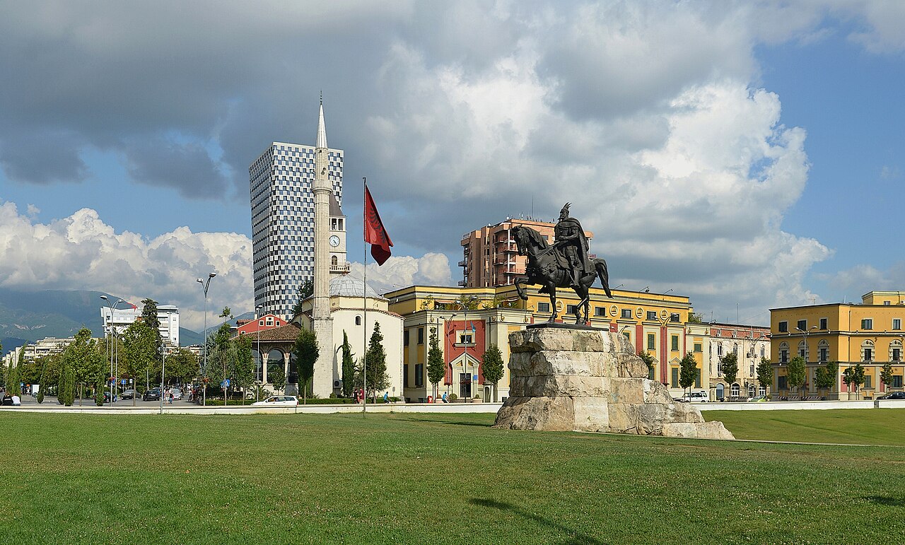
It is the capital's main square and, at the same time, the vantage point from which the city can best be read: from here you can see the Et'hem Bey Mosque, the Clock Tower, the National History Museum with its large mosaic, and the City Hall, all in a single space that blends different eras seamlessly. At its center stands the equestrian statue of George Castriot Skanderbeg, the national hero who in the fifteenth century resisted for decades the Ottoman advance in the Balkans, becoming a symbol of Albanian identity. The square, pedestrianized and redeveloped in the 2010s, is today the venue for public celebrations, seasonal markets and evening strolls, and it is the natural starting point for exploring the city's historic and administrative center on foot.
The Et'hem Bey Mosque, a surviving jewel
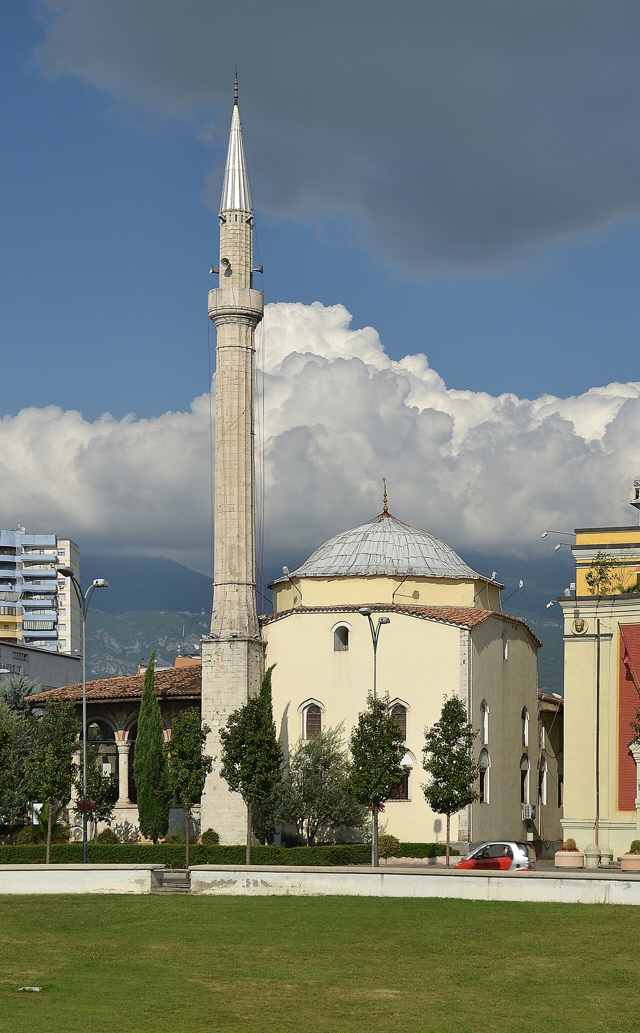
Built between 1789 and 1823 by Molla Bey and completed by his son Haxhi Ethem Bey, this small stone mosque is one of the oldest and most precious religious buildings in the capital, with interior frescoes depicting trees, waterfalls and views of Ottoman bridges, rare examples of figurative decoration in the region's Islamic art. During the years of the communist dictatorship, when Albania officially declared itself an atheist state and thousands of places of worship were closed or destroyed, the mosque survived thanks to its recognized value as a cultural monument, remaining closed to worship but not demolished. Reopened for religious services in 1991, coinciding with the fall of the regime, it now welcomes both worshippers and visitors curious to admire its painted interiors.
The Clock Tower and the vanished bazaar
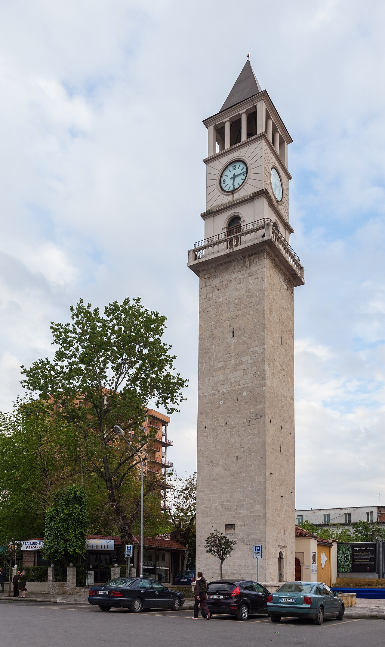
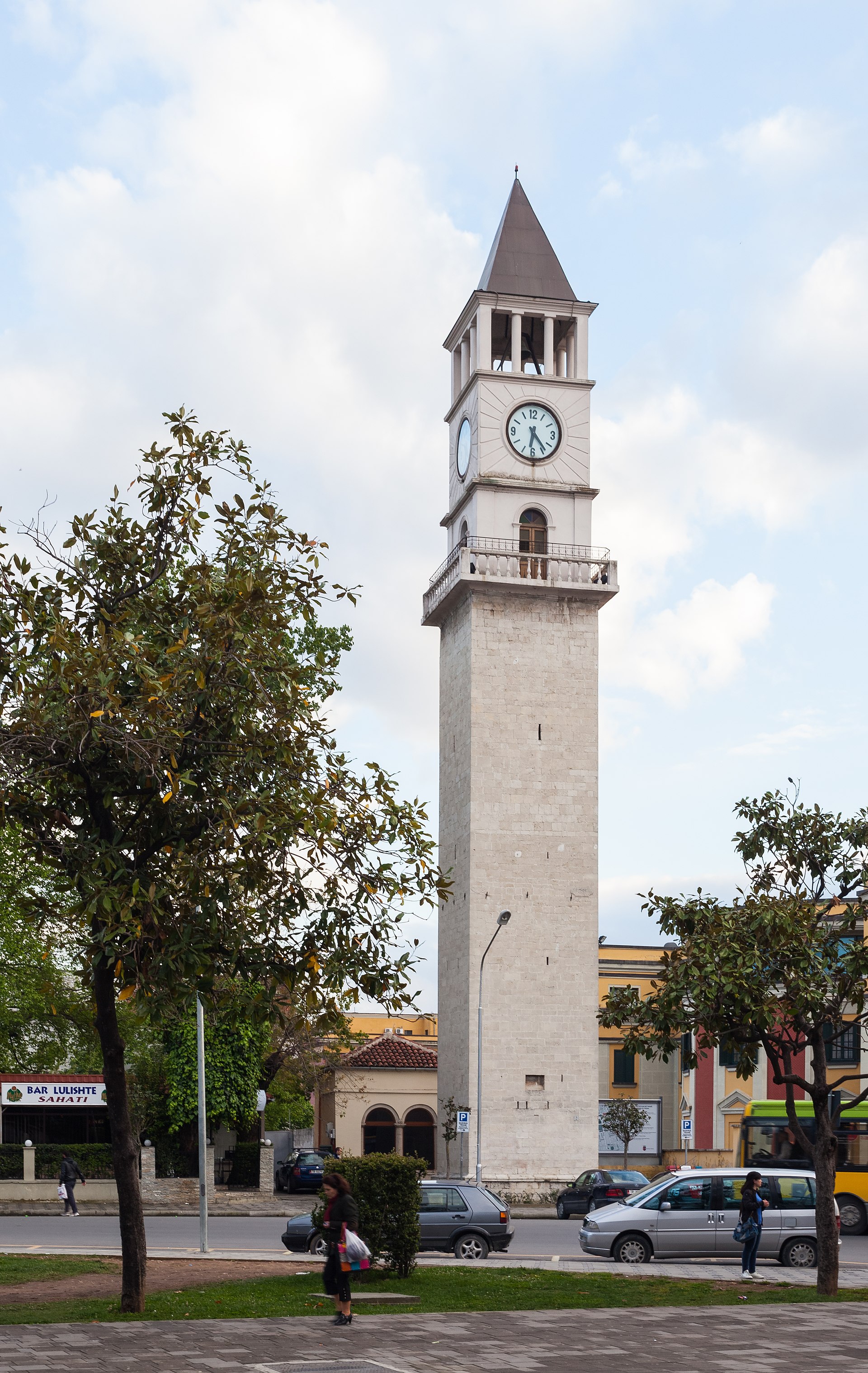
Next to the mosque rises the Kulla e Sahatit, the Clock Tower built in 1822 on the model of Balkan Ottoman towers, about 35 meters tall and for a long time the tallest building in the city. Climbing its narrow steps today offers one of the most complete views over Skanderbeg Square and the rooftops of the historic center. The tower is what remains visible of the old Ottoman bazaar that once occupied much of the area, dismantled during the twentieth-century urban works to make room for monumental avenues; a new covered market, the Pazari i Ri, was built decades later not far from here to give the city back a commercial heart similar to the one it had lost.
The Pyramid of Tirana, from mausoleum to cultural center
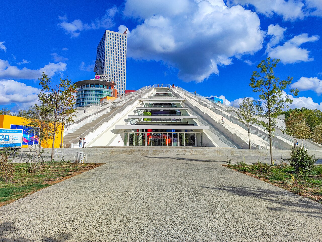
Inaugurated in 1988 as a museum dedicated to Enver Hoxha, who had died three years earlier, the Pyramid is the city's most controversial and debated building: a concrete structure with sharp angular lines, designed by the dictator's daughter together with other architects, meant to celebrate the regime's cult of personality. After 1991 it was converted into a conference center, then left abandoned for years and covered in graffiti, paradoxically becoming a pop symbol of the post-communist city, photographed by anyone visiting Tirana. A recent restoration has transformed it into a center dedicated to technology and creativity for young people, with an outdoor amphitheater and educational spaces, managing to reverse its original meaning without erasing its memory.
Bunk'Art, the underground shelters of the Cold War
Few places tell the security obsession of the communist regime like the anti-nuclear bunkers now turned into museums. Bunk'Art 1, dug into the hills on the outskirts of the city, was the shelter reserved for the party elite in case of a nuclear attack, with hundreds of rooms, operations rooms and even a hall for the people's assembly. Bunk'Art 2, smaller and located in the city center near Skanderbeg Square, was intended for the Ministry of the Interior and today documents the history of the political police (the Sigurimi) through objects, photographs and testimonies. Visiting these cold, labyrinthine spaces is probably the most intense and instructive experience for understanding what it meant to live under one of Europe's most closed dictatorships.
Blloku, from forbidden neighborhood to nightlife hub
Until 1991 Blloku was a fenced and guarded area, reserved exclusively for the top ranks of the communist party and their families: an ordinary citizen could not even approach it without special permission. The villa where Enver Hoxha lived, now open to view from the outside, stands right in this neighborhood. With the fall of the regime, Blloku flipped in the opposite direction, becoming within a few years the liveliest and most cosmopolitan area of the capital, full of cafés, restaurants, boutiques and nightclubs frequented above all by a young generation that here naturally expresses all the longing for normality and openness built up after decades of forced isolation.
Mount Dajti and the cable car over the city
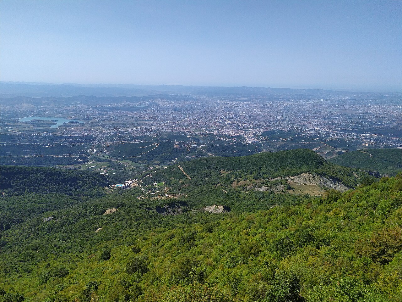
A few kilometers east of the center rises the Dajti massif, over 1,600 meters, which the people of Tirana affectionately call 'the mountain of the Tiranians' because it represents a natural escape from the city's heat and traffic. The Dajti Ekspres cable car, one of the longest in the Balkans, connects the eastern outskirts of the city with the summit plateau in about fifteen minutes, offering panoramas that stretch from the plain of Tirana all the way, on the clearest days, to the Adriatic Sea. On the plateau there are hiking trails, a small nature park, restaurants serving traditional cuisine and, in winter, a small amateur ski slope: an out-of-town trip much loved by families on weekends.
Castles and hinterland villages: Petrelë and the hill villages
About twenty kilometers south of the capital, Petrelë Castle dominates the Erzen valley from a rocky spur, with origins dating back to the Byzantine period and fortifications reworked during the anti-Ottoman resistance of the fifteenth century, when the fortress was part of the defensive network linked to Skanderbeg. Today it houses a small museum and a panoramic inn, and is a popular half-day trip destination from Tirana. Around it, the hill villages of the province such as Tujan, Zall-Bastar and Farkë preserve a rural rhythm made of olive groves, vineyards and small churches, offering a quiet counterpoint to the capital's urban frenzy and a taste of the Albania less told by guidebooks.
The Grand Park and the city's green lung
The Parku i Madh, the Grand Park of Tirana, extends over hundreds of hectares south of the center around an artificial lake created in the 1950s through the volunteer work of students, and is today the capital's main green lung. Woods of holm oak and pine, running and cycling paths, a small botanical zoo and several cafés overlooking the water make it the favorite spot for Tirana residents' Sunday walks. Through the surrounding plain flow the Lana river, which crosses the historic center in a now urbanized channel, and the Tirana and Erzen rivers, which shape the province's agricultural landscape before flowing toward the Adriatic coast.
Flavors, markets and everyday life
Tirana's cuisine gathers Ottoman, Mediterranean and Balkan influences in dishes such as tavë kosi, baked lamb with yogurt and rice, byrek filled with cheese or spinach sold in neighborhood bakeries from early morning, and grilled qofte served in the small taverns of the center. The Pazari i Ri, the new covered market built in the area of the old bazaar, is today the best place to taste local street food, buy seasonal fruit and vegetables from the hinterland, and breathe in the convivial atmosphere typical of Balkan cities. Coffee, often prepared Turkish-style or according to the Italian espresso tradition inherited from the 1930s, remains an essential social ritual at any hour of the day.
When to go and how to experience the province
Spring, between April and June, and early autumn, between September and early October, are the best seasons to visit Tirana: mild temperatures, clear skies ideal for the Dajti cable car, and long days for exploring the center on foot. Summer can be muggy in the city, but it is the perfect season to combine a visit to the capital with excursions to the Adriatic or Ionian coast, just over an hour away by car. Winter, mild compared to other Balkan capitals, still allows you to enjoy the museums, the cafés of Blloku and a possible trip to the snow on Dajti, keeping the city alive all year round.
- Ride the Dajti Ekspres cable car for the panorama over the plain of Tirana
- Visit Bunk'Art 1 and 2 to understand the security obsession of the communist regime
- Admire the Ottoman frescoes of the Et'hem Bey Mosque
- Stroll among the venues of Blloku, the former off-limits neighborhood of the nomenklatura
- Take a trip to Petrelë Castle in the Erzen valley
- Try tavë kosi and byrek in a tavern in the historic center
- Climb the Clock Tower for the view over Skanderbeg Square
- Walk around the artificial lake of the Grand Park
FAQ
Quanto tempo serve per visitare Tirana e la sua provincia?
Come ci si sposta dal centro al monte Dajti?
Dove si parcheggia in centro a Tirana?
Tirana è adatta a una visita con bambini?
Qual è il periodo migliore per visitare la provincia di Tirana?
Si possono visitare i bunker della Guerra Fredda?
Getting there
- Aeroporto Internazionale di Tirana Nënë Tereza, circa 17 km a nord-ovest del centro città
- Rete ferroviaria albanese limitata e in gran parte non operativa per collegamenti passeggeri regolari verso Tirana
- Tirana è il principale snodo stradale del paese: la SH2 la collega a Durazzo e alla costa adriatica in circa 40 minuti, mentre altre arterie la uniscono a Elbasan, Scutari e al sud del paese verso la riviera ionica.
- Per raggiungere il centro dall'aeroporto conviene usare il servizio navetta ufficiale o un taxi con tariffa concordata in anticipo; una volta in città, il centro storico si visita comodamente a piedi.
Perfect for
Bunk'Art, la Piramide e il Blloku raccontano da vicino mezzo secolo di isolamento comunista e la rapida trasformazione degli anni Novanta.
La Moschea di Et'hem Bey e la Torre dell'Orologio conservano l'anima della città prima che diventasse capitale.
Il monte Dajti con la sua funivia e i sentieri sull'altopiano offrono una fuga verde a pochi minuti dal centro.
Il quartiere del Blloku concentra caffè, ristoranti e locali che fanno di Tirana una delle capitali più vivaci dei Balcani.
Il Castello di Petrelë e i villaggi collinari della valle dell'Erzen regalano un'Albania rurale e meno turistica a breve distanza dalla città.
To see
What to see in Tirana
Routes · Trovido Route
